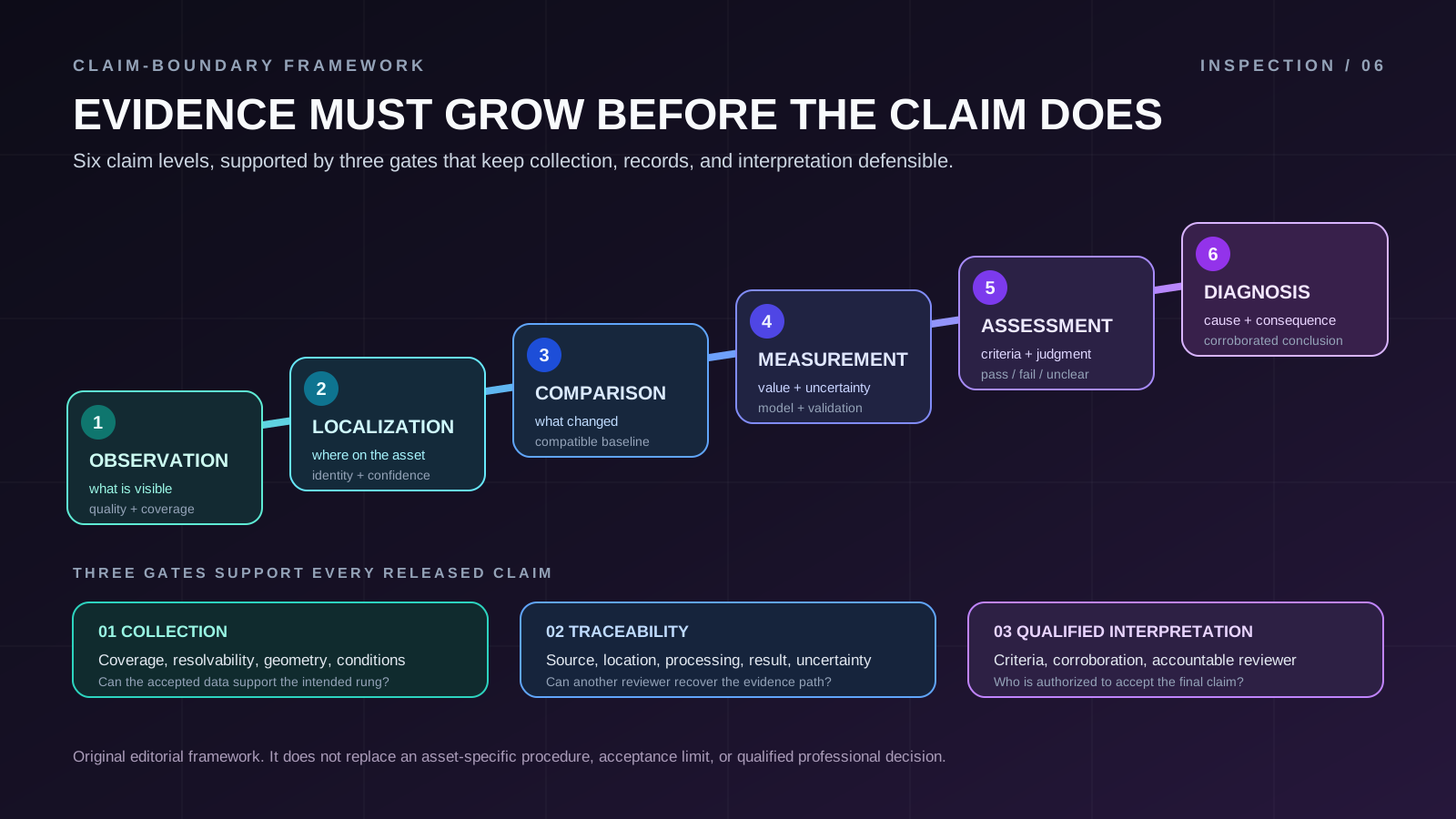
The evidence ladder sets the claim boundary
Each rung changes the statement the deliverable can defend. Higher rungs depend
on the evidence below them, but they also require something new. More pixels do
not supply a missing location record, comparison baseline, measurement model,
acceptance criterion, or causal test.
Scroll horizontally to compare all columns.
The ladder is not a quality ranking. An observation-only deliverable can be
excellent if observation is the contracted purpose. The failure occurs when a
report climbs from one rung to the next without adding the evidence that the
next claim requires.
Level 1: Observation describes the data
An observation says what is visible in the accepted record. "A linear surface
indication is visible in images 1042 through 1046" is an observation. "The
member is cracked" may already imply a physical classification that the image
alone has not established.
The observation rule should be defined before review. It can describe shape,
contrast, continuity, texture, temperature pattern, or another detectable
feature, but it also needs a quality rule. Blur, glare, shadow, saturation,
occlusion, compression, contamination, and a poor viewing angle can make a
feature absent from the record even when it is present on the asset.
The Federal Highway Administration's UAS bridge-inspection research found that
image utility depends on more than nominal resolution. Lighting, camera
settings, platform motion, standoff distance, framing, and inspector judgment
all affected whether the collected image was usable. In its controlled work,
motion blur could make a visible crack difficult to distinguish. The
FHWA data-collection report
is bridge-specific and should not be generalized into a universal sensor
specification, but it demonstrates why observation acceptance belongs in the
collection plan.
Use bounded language when coverage is incomplete. "No indication observed on the
accepted imagery of the listed accessible surfaces" is defensible when the
coverage and exclusions are attached. "No defect exists" is not.
Level 2: Localization connects evidence to the asset
An observation becomes operationally useful when another reviewer can find it.
Localization should identify the asset, component, face or surface, region, and
source record. A latitude and longitude can help, but asset-relative
nomenclature is often more useful for a compact structure and more resilient to
position error.
FHWA's report says bridge defect location records should use the owner's
nomenclature and consistently map an image to a bridge element. It also warns
that GNSS loss beneath a bridge can make image geotags inaccurate or absent. The
report recommends standardized, repeatable tracking so later teams can recover
the location and collect comparable records. This supports a broader principle:
localization is a documented association, not whatever coordinates happen to be
embedded in a file.
A localization record can include:
- asset and component identifiers using the owner's controlled vocabulary;
- face, orientation, station, span, bay, grid, or another asset-relative
reference;
- source file identifiers and the sequence or view in which the indication
appears;
- coordinate reference system and position source when coordinates matter;
- camera pose or viewing-direction information when it can be supported;
- a stated confidence or limitation when location data are indirect, degraded,
or manually reconstructed.
Do not let false coordinate precision conceal a weak association. A rounded
asset-relative location with a recoverable image trail can be more useful than
many decimal places derived from an unreliable position fix.
Level 3: Comparison requires compatible records
Side-by-side images are not automatically a change measurement. A comparison
claim needs evidence that the records represent the same physical region with
enough compatibility to separate asset change from collection and processing
change.
Viewpoint, range, focus, illumination, surface moisture, thermal state, lens
behavior, image processing, coordinate reference, and registration can all alter
appearance. The relevant controls depend on the sensing method and the question.
The report should state which factors were controlled, normalized, measured, or
left as limitations.
USGS developed its
UAS imagery calibration guidance
so quantitative datasets could be calibrated, quality controlled, and made more
comparable. USGS identifies tie-point quality and ground-control accuracy as
contributors to geometric accuracy regardless of nominal ground sample distance.
It also recommends retaining calibration parameters and their uncertainties in
metadata. That does not mean every inspection needs a survey workflow. It means
a comparison method has to match the strength of the change claim.
For a qualitative comparison, an acceptable claim might be: "The indication
occupies a larger visible region than in the accepted baseline under the stated
view and lighting limits." For a quantitative change claim, define the
registration method, the quantity being compared, validation checks, and a
change-detection threshold that accounts for uncertainty. If the observed
difference does not clear that threshold, report it as indeterminate rather than
growth.
Level 4: Measurement defines the property and uncertainty
A measurement is not a number placed on an image. It is a result for a defined
property, produced through a stated method and accompanied by an evaluation of
uncertainty.
"Crack size" is not a sufficient measurand. The visible surface-trace length,
estimated opening width at a named location, and area of a segmented surface
indication are different properties. They depend on different geometry,
resolution, algorithms, references, and assumptions.
NIST Technical Note 1297
explains that a measurement result is complete only when accompanied by a
quantitative uncertainty statement. NIST also distinguishes error from
uncertainty. Correcting a known systematic effect does not remove uncertainty
about that correction or about the other inputs to the result.
For an image-derived dimensional result, the measurement record should include:
- the precisely defined measurand and unit;
- the source pixels, points, or surface region used;
- sensor and lens configuration, image settings, and relevant environmental
conditions;
- scale, control, calibration, and reference information;
- acquisition geometry, transformations, software, and processing parameters;
- validation against independent check information appropriate to the method;
- excluded observations and quality-control failures;
- the reported value, uncertainty statement, and acceptance limit for the
intended use.
Nominal ground sample distance is one input, not an accuracy guarantee. A pixel
footprint does not account for blur, oblique geometry, lens distortion,
registration, control quality, surface reconstruction, feature labeling, or
processing choices.
NIST's
metrological traceability policy
adds two essential boundaries. Traceability is a property of a measurement
result, supported by a documented chain of calibrations that contribute to
uncertainty. It is not a property conferred on every result by owning a
calibrated instrument. NIST also states that traceability alone does not ensure
fitness for purpose because the uncertainty may still be too large for the
decision.
Level 5: Assessment applies named criteria
Assessment interprets the accepted evidence against a defined criterion. It
might assign a condition category, determine whether a project tolerance was
met, or identify an item for follow-up. The criterion must be named and current,
and the reviewer must be authorized and qualified for that decision.
A scope risk appears here: imagery collection can be mistaken for authority to
assess. A classifier can label a region, and software can rank confidence, but
neither establishes that the relevant asset criteria were complete or correctly
applied. The report should preserve the algorithm output as evidence, record its
version and review path, and identify who accepted, changed, or rejected the
assessment.
Bridge inspection supplies a concrete regulatory example. For highway bridges
subject to the National Bridge Inspection Standards, current
23 CFR 650.313 inspection procedures
require inspections to determine condition, identify deficiencies, and document
results. For initial, routine, in-depth, and fracture critical member
inspections, a team leader who meets the applicable qualifications must be at
the bridge and actively participate. The rule also requires documented
quality-control and quality-assurance procedures. Those requirements do not
apply to every type of asset, but they show why collecting the image and
accepting the condition conclusion are distinct responsibilities.
An assessment may properly conclude "indeterminate." That is a useful result
when coverage, evidence quality, method capability, or criteria do not support a
stronger decision.
Level 6: Diagnosis adds cause and consequence
Diagnosis attributes an observed condition to a supported mechanism or cause and
connects it to an action or consequence. That can require design and maintenance
records, loading history, material knowledge, tactile examination,
nondestructive evaluation, electrical testing, laboratory analysis, destructive
sampling, or other evidence unavailable from the aerial sensor.
FHWA's
NBIS inspection guidance
draws this boundary directly for highway bridges. The agency says UAS may
supplement portions of an inspection but cannot address every aspect, including
auditory cues and tactile methods such as sounding. If aerial photography shows
concerning change, FHWA says the inspector must investigate further with
physical techniques. The page also states that its questions and answers are
guidance about existing requirements, not independently binding law.
Editorial inference: The same reasoning applies outside bridge work without
importing the bridge rule itself. A warm region in a thermal image is a
temperature pattern. A dark region in visible imagery is a reflectance pattern.
A geometric discontinuity in a point cloud is a model feature. Each can justify
targeted follow-up. None identifies a root cause merely because software
attaches a familiar label.
If the evidence supports a suspected mechanism but not a diagnosis, say so.
"Pattern consistent with more than one mechanism; targeted testing required" is
stronger than a confident label the available method cannot defend.
Gate 1: Collection must be fit for the intended claim
The collection gate asks whether the planned data can support the chosen rung.
It should be passed before routine production collection, then checked again in
the field as conditions change.
Start with the decision and work backward:
- Name the claim level and the decision that will use it.
- Define the asset surfaces and smallest relevant feature or property.
- Set observable, testable acceptance criteria for coverage and data quality.
- Select the sensing method, geometry, control, and environmental window.
- Identify conditions that force recollection, qualification, or escalation.
- Prove the end-to-end method on representative conditions before relying on
production data.
The collection plan should address resolvability, not just file dimensions. It
should include coverage, focus, motion, compression, exposure, view angle,
occlusion, surface state, and method-specific environmental conditions. For a
repeat survey, it should also specify what must remain comparable.
Payload behavior is part of the measurement chain. The
payload integration interface gate
shows why focus, timing, orientation, power, data integrity, and calibration
need to survive integration with the aircraft. A capable sensor on a poorly
controlled interface does not produce a defensible inspection result.
Field quality control should answer a practical question while recollection is
still possible: did every required surface produce data that pass the stated
acceptance rule? A thumbnail review or live video can help direct collection,
but it should not be treated as proof that the full-resolution source meets the
deliverable requirement.
Gate 2: The evidence chain must be recoverable
Inspection traceability and metrological traceability overlap, but they are not
identical.
Inspection traceability, as used in this framework, is the evidence lineage from
the asset and collection event to the source file, processing steps, review, and
reported claim. It lets another reviewer recover what happened. Metrological
traceability is the narrower formal property of a measurement result described
by NIST. It requires the measurement result to connect to a specified reference
through a documented calibration chain, with each link contributing to
uncertainty.
A practical evidence chain records:
Scroll horizontally to compare all columns.
Do not rewrite original metadata silently. If a geotag, timestamp, component
label, or calibration reference is corrected, preserve the original record and
record the correction, author, basis, and time. The goal is not paperwork for
its own sake. It is the ability to reconstruct the evidence path when a later
inspection, dispute, or safety decision depends on it.
Gate 3: Qualified interpretation controls the final claim
The interpretation gate assigns responsibility before results arrive. It names
who may make observations, approve measurements, apply condition criteria,
diagnose mechanisms, and accept the deliverable. The roles may be held by one
person or several people, depending on the asset, jurisdiction, method, and
organization.
For assessment and diagnosis, the review package should include the relevant
evidence rather than only a model overlay or summary table. It should expose
quality failures, alternate explanations, comparison limits, and conflicting
results. A reviewer cannot exercise accountable judgment over evidence they
cannot inspect.
Automation can prioritize records or propose labels. It should not silently
expand the contracted evidence level. Record the model and threshold, the domain
in which performance was validated, the disposition of rejected or changed
outputs, and the human or organizational authority accepting the final claim.
Acceptance examples make the scope testable
The following examples illustrate claim boundaries. They are not universal
tolerances or asset-specific inspection instructions. The responsible owner and
qualified professionals must set numeric thresholds and governing criteria.
Scroll horizontally to compare all columns.
These statements change procurement and field behavior because they are
verifiable. "Provide detailed imagery" is not verifiable until detailed enough
for what, on which surfaces, under which conditions, and with which failure
response are defined.
Write the deliverable before the collection plan
A bounded observation scope can use language like this:
Collect reviewable visible-light imagery of the accessible exterior surfaces
identified in the controlled coverage map. Document visible surface
indications at the time of collection and associate each indication with the
asset region and source files. Report unobserved areas and quality failures.
Do not infer hidden condition, physical dimensions, material capacity, root
cause, or compliance from imagery alone.
If localization is required, add the asset coordinate system, component
nomenclature, association method, and confidence rule. If comparison is
required, add the baseline, compatibility controls, registration validation, and
detection threshold. If measurement is required, add the measurand, reference,
uncertainty method, validation checks, and acceptance limit. If assessment or
diagnosis is required, name the governing criteria, corroborating methods,
qualified role, and approval record.
The resulting deliverable should separate evidence from interpretation:
- Scope, claim levels, criteria, revisions, and named responsibilities
- Coverage and limitation map, including every unobserved or rejected area
- Source-data index and evidence lineage
- Observation, localization, comparison, and measurement records
- Assessment and diagnosis records with criteria, reasoning, and approval
- Exceptions, follow-up actions, and unresolved questions
Final claim-boundary review
Before releasing an aerial inspection deliverable, ask:
- What exact decision will use each reported claim?
- Which ladder level does each claim occupy?
- Did collection pass the acceptance rule for that level?
- Can another reviewer recover the asset region, source data, processing, and
reviewer?
- Does each comparison distinguish asset change from method change?
- Does each measurement define the measurand, value, unit, validation, and
uncertainty?
- Does each assessment name the criterion, revision, and qualified reviewer?
- Does each diagnosis include the necessary corroboration and competing-cause
review?
- Are unobserved areas, failed data, uncertainty, and indeterminate results
visible?
- Would the wording remain defensible if the reader saw the complete evidence
package?
Aerial inspection is valuable because it can create repeatable, reviewable
evidence from useful viewpoints. Its credibility depends on stopping each claim
where the evidence stops. A narrow observation or measurement that survives
review is more useful than a broad diagnosis assembled from pixels alone.